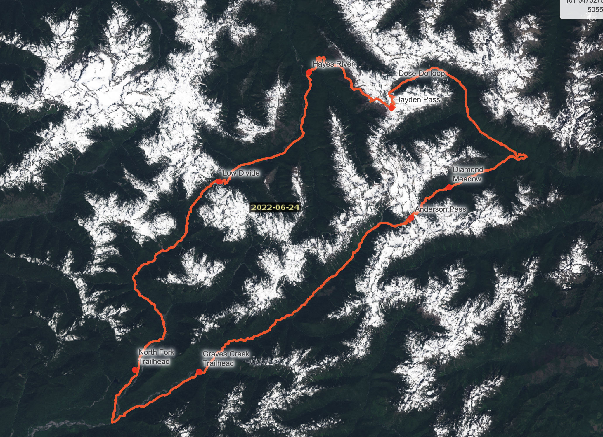
Fastpacking Olympic National Park - The Dose-Doe Loop

Susie cruising toward Hayden Pass on day 2
"Are you used to hearing these kinds of warnings?" Susie asked me as we left the Lake Quinalt Ranger Station.
"Yeah, I've heard them a bunch" I replied, trying to ease her mind.
We were at the ranger station making some adjustments to our permit. The campsites we had chosen were too far apart to book online. After sharing our plans with one ranger, he disappeared into the station and returned with a companion to give us the talk. Trail crews hadn't visited the areas we were headed and they wanted to ensure we knew about snowed-in passes, blowdown, and river crossings.
As we left the ranger station, excitement swelled within me at the chance to get off the well-worn track for three days in the wilderness. Susie seemed a bit more skeptical.

Enchanted Valley
With the long July fourth weekend stretching out before us, we were looking for a fastpacking adventure worthy of our precious vacation. Originally we'd planned on trying out a ridge traverse in the Wallowas or Olympics, but persistent snow in the alpine had us looking for low altitude options. I'd been to the Olympics on a handful of trips before and have fallen in love with the big terrain and solitude.
We looked for a long route to take us to some seldom visited areas of the park. Originally, we considered a North-South traverse of the park via the Elwha and North Fork Quinalt Rivers, something I've since learned is called the "Press Expedition". A long car shuttle put us off that option. I sketched out a few options and toggled back and forth between map layers in Caltopo, using the park planning map and a recent satellite flyover.

Trail to Anderson Pass
We cruised down the long river trail, jogging the flat sections and downhills, switching to walking when the trail pitched up. "White Creek up ahead is going to be the crux of your trip" the ranger in Enchanted Valley told us.

More hooves and paws than boots on this stretch

Some of the best trail of the trip was the most remote. Running buttery smooth singletrack alongside the Dosewallips river, we met a lone photographer descending from Bear Camp. We asked him about Hayden pass but he hadn't made it above his camp. He warned us that he expected the snow started just above his high point. His demeanor hinted he rather preferred his solitude so we left him alone and went on our way.

Night one - Diamond Meadow camp on the West Fork Dosewallips River
After learning my lesson the hard way, I always plan loops to locate the crux before the halfway point. With this loop, 5800 foot Hayden Pass was smack in the middle. When we woke up on day two, we knew we might hit early snow or blowdown and have to end the trip by retracing our route. But luck was with us this time, we found clear trail and didn't hit snow until 4800'.
With no hanging cornices to threaten the route and perfect bootpacking conditions, we opted to climb the snow directly to Hayden Pass rather than following the trail's switcbacks.

Route Info - Dose-Doe Loop
For trips in Olympic National Park, see their Wilderness Trip Planner. Book backcountry camping at recreation.gov. If you're traveling more than about 10 miles/day, you'll need to talk to the Olympic Wilderness Information Center (WIC), you’ll find their contact info in the planner. In this and previous trips to the Olympics, I've found the WIC rangers to be knowledgeable, helpful, and excited about people adventuring in Olympic.


Date: July 1-3, 2022
Distance: 80 miles (+9 mile dirt road run/hitchhike/shuttle to connect trailheads.)
Vertical: ~15k feet of climbing
Navigation: We each used Caltopo and Gaia on our phones, in the future I'd print a map for backup
Wildlife: 5 bears, 2 bull elk, several deer, and 1 very aggressive mama grouse
To assess snow levels, I used Caltopo’s Satellite layers. The most recent clear flyover I could find was from 6/24
For notes on how to use Caltopo and GaiaGPS to assess snow levels, see this post
Gear

I made a video showing all the gear I used for this trip, check it out here.
Safety
This is a big route with highly variable conditions and a large commitment factor. Be careful. Don’t bite this off it you’re not confident in your abilities to assess conditions and retrace your route if needed.

Bootpack to Hayden Pass
We crested Hayden Pass to an expansive view of the Olympic Range, a carpet of Avalanche Lillies, and mostly clear trail all the way to the Elwha Valley floor.

Taking in Mount Olympus from the dry side of Hayden Pass

Abundant Avalanche Lilies
On the morning of the third day we spread our meager food stash on the bank of the Elwha River. I handed a couple bars to Susie, regretting not taking a closer look at her food packing before we started. We'd started rationing on day two but it looked like we'd make it to the trailhead on fumes.

Night 2 - Hayes River Camp on the Elwha River
"We were told we needed crampons to get over Low Divide, and the river crossing at 16 mile is supposed to be deep." An English woman trailing her intrepid family near Chicago Camp warned us. It was day 3 and we were well committed now. "Me met one guy who crossed the river, but he did it first thing in the morning". We looked at our watches. Early afternoon. We smiled at the woman, smiled at each other, and continued on.
Choose your own adventure
Over the course of the trip we continued to receive well-intentioned warnings about conditions ahead. Over the years I've learned to hold other people's condition reports lightly, they tend to vary so widely that they make good entertainment but generally poor information.

Typical river crossing
We crested Low Divide to a few small patches of snow (crampons??), were treated to our fifth black bear sighting. Stomachs grumbling we battled brush and blowdown, but no other people, out the North Fork Trail. In the 40 trail miles between Dose Forks and Elip Creek, we saw five people.
We reached the North Fork Trailhead and I set off to run the dirt road to our start point while Susie waited. Reflecting on the trip I found the perfect mix of elements. Uncertainty, scrappy trail, and smooth runnable singletrack. This is how I most like being in the mountains; light pack on my back, companion by my side, and miles to go before we sleep.
